The magnetic declination calculator tells you the difference between true north and magnetic north at your location.
We use magnetic declination for many applications, including navigation, orienteering, planning, and not getting lost! If all you have is a compass and your location, you can find true north using the magnetic declination calculator.
Read on to find your way through questions like:
- What is magnetic declination?
- What is the magnetic declination at my location?
- What is the difference between true north and magnetic north?
- What is the magnetic declination at my location?
- How to adjust for magnetic declination on a topographic map?
Our calculator is adapted from C software provided by the National Oceanic and Atmospheric Administration (NOAA) and is currently updated for the years 2025 to 2029.
What is magnetic declination?
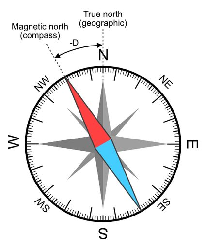
Magnetic declination is the angular difference between true north and magnetic north on the horizontal plane.
True north is also known as the geographic north pole. If you think about a model globe, true north is the "top" point of the globe, aligned with the Earth's axis.
Magnetic north is the point in the Earth's Northern Hemisphere where the magnetic field points vertically downwards. Your compass points towards magnetic north. If you are navigating by compass, you should correct for magnetic declination as a compass can point up to 20 degrees off from true north, depending on your location!
While true north is a fixed point, the location of magnetic north moves over time. Our calculator will help you find the magnetic declination for your specific location and date.
A positive declination (+D) means that your compass will point east of north.
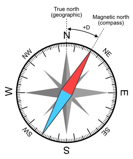
A negative declination (-D) means that your compass will point west of north.
How do I find my elevation?
When using the magnetic declination calculator, you need to know your latitude, longitude, elevation, and the date. You can easily find your latitude and longitude by typing in your city's name with the words "longitude and latitude" into your favorite search engine.
For elevation, you may be familiar with the concept of elevation above mean sea level (AMSL). However, our magnetic declination calculator currently uses elevation above the WGS84 ellipsoid, also called height above ellipsoid (HAE), which is the same model used by GPS devices. This is simply because mean sea level varies around the Earth due to differences in the gravitational field: when we calculate the gravitational force considering Earth's mass distribution, we find different values for across the surface!
The good news is that most smartphones nowadays contain built-in GPS devices, so you can find your GPS altitude from anywhere if you have a smartphone. Be mindful that most altitude apps will convert elevation into "above mean sea level" and present only the AMSL elevation. One example app that gives the original GPS altitude is (for Android).
However, in a pinch, you can and use your elevation above mean sea level instead of height above the ellipsoid, as the difference for magnetic declination is negligible according to NOAA:
The difference between AMSL and HAE varies with location, and the total variation is less than 200 meters... The correction results is a difference of magnetic field strength of about 1-3 nT... However, the effect of geoid height correction is negligible in the magnetic declination."
How to find true north using magnetic declination?
Once you know the current magnetic variation for your location and date, you can find true north. First, make a note of how many degrees magnetic north is from true north using the magnetic declination calculator.
Holding your compass, turn your body until the compass needle points to the magnetic declination in relation to north. Once the needle is pointing at the magnetic declination, the north arrow of the compass will be pointing at true north.
Remember that a positive declination means your compass needle should point east of north while a negative declination means your compass needle should point west of north.
How to adjust for magnetic declination using a map?
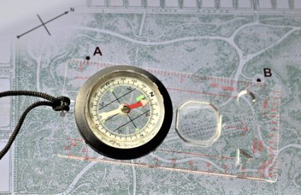
So you've found your magnetic declination, but how do you use it with a map? Let's say you have a map and compass, as in the picture below, and want to know how to get to a certain landmark. You planned ahead and found that the magnetic declination for your location is .
-
Align the compass ruler from point A to point B on the map.
-
Keeping the ruler in place, spin the compass so that the north label on the compass points in the same direction as the north arrow on the map.
-
Read the compass bearing (direction) that the ruler's arrow lines up with. In the picture below, the bearing is .
-
Remove the compass from the map. With the compass in your hand, turn your whole body until the compass needle points to the magnetic declination of . At this point, you have aligned your compass, which means the north marking on the compass is pointing at true north.
-
Walk in the bearing direction you noted in Step 3 () to reach your destination.
Some maps will have already calculated the magnetic declination (for a given date) as part of the legend. It is sometimes marked with the abbreviation "MN" for "magnetic north" to indicate how to orient your compass with respect to the map. This is especially common in orienteering maps.
Now that you know how to find the magnetic declination on a topographic map, you're one step closer to becoming a true navigation expert!
🙋 Are you interested in other geography-related tools? Visit the lat long to utm converter. the coordinates converter, or the latitude longitude distance calculator!
Credits
The magnetic declination calculator is based on the World Magnetic Model 2020 (WMM2020) provided by NOAA, written by Manoj C. Nair and Adam Woods, and adapted for Javascript by Jasmine J. Mah. The WMM2020 Coefficient file is valid for 2025.0 - 2030.0, and we have verified our calculator using the test values provided by the NOAA.
If you're looking for the technical details behind the question "How do you find magnetic declination?" You can read in-depth about the mathematical formulas in the .